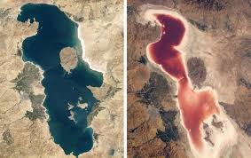
Satellites are no longer just tools for navigation or weather forecasting—they have become critical instruments for monitoring climate change. With advanced sensors and imaging technologies, satellites provide real-time data that helps scientists track environmental changes and predict future impacts.
1. The Role of Satellites in Climate Monitoring
Satellites observe Earth from space, collecting data on:
- Atmospheric composition: Greenhouse gas concentrations like CO₂ and methane
- Temperature changes: Global land and ocean surface temperatures
- Ice and snow coverage: Glacial melting and sea ice reduction
- Deforestation and land use: Changes in forests, wetlands, and urban areas
- Sea level rise: Coastal flooding risks and ocean currents
These measurements offer a comprehensive, continuous view of Earth’s climate system that ground-based monitoring alone cannot provide.
2. Benefits of Real-Time Climate Data
- Early warning systems: Satellites detect extreme weather events, such as hurricanes, floods, and wildfires, providing vital alerts.
- Policy-making support: Governments and organizations use data to inform climate policies and mitigation strategies.
- Scientific research: Continuous monitoring improves climate models, helping predict future environmental changes more accurately.
- Global collaboration: Satellite data is shared internationally, enabling coordinated responses to climate threats.
3. How Satellite Technology Works
- Remote sensing: Satellites use radar, lidar, and multispectral imaging to collect detailed environmental data.
- Data processing: AI and machine learning analyze vast amounts of data to identify trends and anomalies.
- Visualization tools: Maps, charts, and models help scientists and the public understand complex climate changes in real time.
4. Real-World Impacts
- Monitoring ice sheets in Greenland and Antarctica to measure melting rates
- Tracking deforestation in the Amazon rainforest
- Observing urban heat islands and air quality in major cities
- Providing early alerts for droughts and water scarcity
These insights allow governments, businesses, and communities to respond proactively rather than reactively to climate challenges.
5. The Future of Climate Satellites
Next-generation satellites are becoming more precise, affordable, and accessible, enabling finer-scale monitoring. As technology advances, real-time climate data will be even more actionable, supporting climate adaptation, renewable energy planning, and environmental conservation.
Final Thoughts
Satellites are transforming how we understand and respond to climate change. By providing real-time, accurate data, they empower scientists, policymakers, and communities to take informed action and mitigate environmental risks.